Jun 22 2011
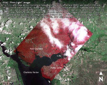
A multispectral imager built by FluxData, Inc., a leading manufacturer of multispectral systems, has successfully captured its first high-resolution image from space. The western coastal region of Florida was imaged on June 10, 2011 from 250 miles above the earth by the International Space Station Agricultural Camera (ISSAC).
The imaging sensor assembly of ISSAC is based on FluxDataʼs FD-1665 3CCD Multispectral camera technology. The systemʼs Green, Red and Near-infrared spectral response bands were selected to emulate those of the Landsat 7 satellite and provide many of the same benefits for vegetation and moisture discrimination, monitoring and identification.
Through University of North Dakotaʼs (UND) Imagery Request & Information System (IRIS), ISSAC will provide end-users the ability to use Google Earth browser plug-in to select specific geographical areas of interest and request the collection of imagery that will be downlinked, processed, and delivered within just 1 to 2 days. The data and information ISSAC provides will be used for a wide range of activities including: nitrogen application maps to improve fertilizer use, agriculture management zone decision support systems to improve nutrient and invasive species management, and rangeland management tools to improve livestock allocation and evaluation.
Doug Olsen, Project Manager for ISSAC at UND, states, “This is a successful culmination of a decade-long program. FluxData provided an upgraded sensor to UNDʼs specification that can image the Earth with significantly higher resolution than its predecessor. In fact, the system is capable of producing images on par with NASAʼs LandSat satellites and is useful for not only farmers and agriculture producers, but can be applied to rapid-response imaging of natural disasters.”
Lawrence Taplin, CTO of FluxData, states, “We are pleased that the hard work we put into making improvements to the systemʼs optical and mechanical design to withstand the environmental rigors of a payload launch and meet requirements for in-station safety, electromagnetic interference, shock and vibration have paid off and the system has commenced operation.”
Pano Spiliotis, CEO of FluxData, said, “We are proud that our sensor technology has passed the rigors of a space launch and now can provide continuous images for research, educational and rapid response natural disaster uses. The ISSAC program has been an important milestone for FluxData in that it has confirmed the performance of FluxDataʼs products and systems engineering capabilities. We look forward to future projects with academic, government and private companies on more of these challenging engineering programs.”