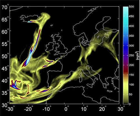
The ash cloud from the Icelandic volcano Eyjafjallajökull reached the Iberian Peninsula, airspace was temporarily closed and airports came to a standstill all over Europe in May 2010. The path of the volcanic cloud was followed at that time by scientists using laser detectors sun photometers, satellites, and other equipment. Two years later, the results and models that will enable aversion of such consequences due to such natural disasters have been published in the Atmospheric Environment Journal.
 The models aim to predict the evolution of volcanic ash clouds, like the one emitted by Eyjafjallajökull. Credit: FLEXPART/NILU.
20 March 2010 witnessed the eruption of the Eyjafjallajökull volcano in the south of Iceland. A cloud of ash was formed that made its way towards Central and Northern Europe causing closure of airspace. On 3 May, winds transferred the aerosols, which are a mixture of gas and particles towards Portugal and Spain resulting in shutdown of certain airports between May 6 and 12.
Researcher at the Spanish Research Centre for Energy, Environment and Technology (CIEMAT), Arantxa Revuelta stated that the economic impact caused by this event resulted in the dire need for accurately explaining the path of a volcanic plume in the atmosphere. The particle composition and concentration limits need to be clearly determined to ensure safe navigation, he added.
The volcanic ash cloud was detected by the research team as it went over Madrid by using the Light detection and ranging (LIDAR) equipment, which is highly effective for the assessment of aerosol concentration at high altitudes. The CIEMAT station belongs to the European Network, European Aerosol Research Lidar Network (EARLINET) and is one among 27 stations that use this system.
The research team targeted a laser beam skyward using LIDAR technology and the signal received offered information on the physical and chemical properties of the particles. It was determined that the maximum aerosol value was 77 µg/m3 which is lesser than the risk value set for air navigation, which is 2 mg/m3.
The levels of particles with high sulphate content shot up though the particles were very fine. The thicker particles are ash and may affect aircraft motors whereas the fine matter may have hazardous health impact but may not affect air travel.
NASA’s AERONET comprising a number of tracking stations in Portugal and Spain with the help of automatic sun photometers tracked the particle evolution. The focus of these instruments is sunward and data is collected every hour on the optical thickness of aerosols and their size distribution in the atmospheric column.
Data collection is improved while using both LIDAR technology and sun photometers. It was found that there is a great difference between the characteristics and size of the volcanic aerosol particles over consecutive periods.