Mar 15 2010
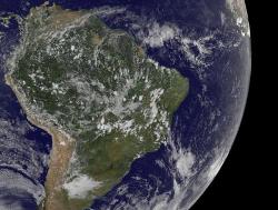
The second–ever known tropical cyclone in the South Atlantic Ocean can't escape satellite eyes, and today, the Geostationary Operational Environmental Satellite, GOES-12 captured a visible image of Tropical Storm 90Q now located off the coast of Argentina.
 The GOES-12 satellite captured a visible image of South Atlantic's Tropical Storm 90Q at 1745 UTC (12:45 p.m. ET) off Argentina's coast.
GOES-12 satellite captured an image of Tropical Storm 90Q at 1745 UTC (12:45 p.m. ET) today, March 12, when it was more than 1,350 miles east of Buenos Aires, Argentina, approximately near 36.5 degrees South latitude and 34.8 degrees West longitude. At 10 a.m. ET today, Tropical Storm 90Q still had maximum sustained winds near 46 mph (40 knots).
GOES-12 is operated by the National Oceanic and Atmospheric Administration, and images are created by NASA's GOES Project, located at NASA's Goddard Space Flight Center, Greenbelt, Md.
Tropical Storm 90Q is now moving quickly in a southeasterly direction and is starting to interact with a mid-latitude frontal system. By the end of the weekend, the Southern Atlantic Ocean's second tropical storm in recorded history is expected to be merged with a cold front and just remain in the history books.