Dec 26 2014
The tropical low pressure area previously known as System 95S organized and strengthened into Tropical Cyclone Kate on Dec. 24 and the Cocos Keeling Islands are expected to feel its effects on Dec. 25 and 26. NASA-NOAA's Suomi-NPP satellite passed over Kate after it formed.
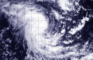
 NASA-NOAA's Suomi NPP satellite flew over Tropical Cyclone Kate on Dec. 24 at 6:39 UTC (1:39 a.m. EST) after it formed in the Southern Indian Ocean. Image Credit: NASA/NOAA
NASA-NOAA's Suomi NPP satellite flew over newborn Tropical Cyclone Kate on Dec. 24 at 06:39 UTC (1:39 a.m. EST) and the Visible Infrared Imaging Radiometer Suite or VIIRS instrument aboard captured a visible image of the storm. The VIIRS image showed strong thunderstorms around the center of circulation. There was also a large band of thunderstorms south of the center wrapping into it from the southwestern quadrant.
VIIRS is a scanning radiometer that collects visible and infrared imagery and "radiometric" measurements. Basically it means that VIIRS data is used to measure cloud and aerosol properties, ocean color, sea and land surface temperature, ice motion and temperature, fires, and Earth's albedo (reflected light).
According to the Australian Bureau of Meteorology (ABM), at 8:00 pm WST local time (7 a.m. EST) on Dec. 24, Tropical Cyclone Kate had maximum sustained winds near 65 kilometers per hour (40 mph). It is centered near 10.9 south latitude and 98.4 longitude, or about 225 km (139.8 miles) northeast of Cocos Island. Kate is moving to the west-southwest at 19 kph (11.8 mph).
ABM says "The system has intensified and has been name Tropical Cyclone Kate. It is possible that gales will commence on the [Cocos] islands before sunrise Thursday, Dec. 25 (Christmas Day). The period of greatest risk is likely to be during the afternoon and evening on Christmas Day.
ABM stated that cyclone impacts for the Cocos Keeling Islands should be expected during Christmas and Boxing Day. The Australian Federal Police have advised a Blue Alert for communities on Home and West Island. ABM noted that the center of the tropical cyclone is expected to pass close to the islands during the afternoon of Dec. 25 (local time) and will cause very rough seas as it approaches the Cocos Keeling Islands.